|
Various recommendations, scoured from various people/places &
personal experience.
Tracks can be found here, karting tracks here, the following are road routes. The Top Gear guide to secret street circuits throughout Europe can be found here (PDF), and an index of tracks worldwide can be found here
There are some useful travel tips given here
A guide to the roads around the Nurburgring can be found here
The road maps have been organised as follows:
Other notable world class drives:
USA
- Las Vegas to Salt Lake City - Vegas (Nevada) through the Virgin River Gorge, skimming Arizona, and on to Utah's Zion NP, Bryce NP & Capitol Reef NP. Optional detour to The Arches NP (Moab). See here for National Park pass details, and here for details on the NPs
-
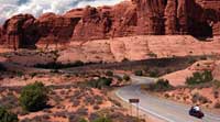 The Red Rock Scenic Road winds through Sedona’s Red Rock Country, sometimes called a “museum without walls”. The road provides a stunning view of the red rocks. The Red Rock Scenic byway also passes through the Montezuma Castle National Monument and the Coconino National Forest. The Red Rock Scenic Road winds through Sedona’s Red Rock Country, sometimes called a “museum without walls”. The road provides a stunning view of the red rocks. The Red Rock Scenic byway also passes through the Montezuma Castle National Monument and the Coconino National Forest.
- Nevada
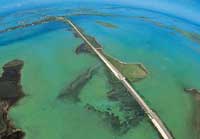 Miami to Key West (257km). Completed in 1938 along the course of a railroad that had been destroyed by a hurricane, the Overseas Highway (Route 1) leaps from island to island across 42 bridges through the Florida Keys. Miami to Key West (257km). Completed in 1938 along the course of a railroad that had been destroyed by a hurricane, the Overseas Highway (Route 1) leaps from island to island across 42 bridges through the Florida Keys.
The journey, mostly over water, can take less than four hours, although it can take longer if you stop to enjoy the views.Go early in the morning, when the light is at its best and the commuter traffic is flowing in the other direction.- Route from Miami, stopping at Islamorada Fish Company at Milemarker 81.5, and Sloppy Joe’s bar on Duval Street, Key West. Click here for the Times article.
- The Carolina Crossing: Charleston to Cherokee (1,600km). Click here for the Times article.
- NEW ENGLAND IN FALL: Litchfield to Lincoln (400km). Click here for the Times article.
- Key West Alternative - The Tamiami Trail. Distance: 275 miles in 2 days
From Tampa to Miami through Gibsonton, a retirement community for sideshow freaks - see the Showtown Bar and Grill. Continue south along the Redneck Riviera to Fort Myers Beach and on to Naples. Spend the night in Everglades City at the Rod and Gun Club Stop off at America's smallest post office (mile marker 79.1), the Skunk Ape Research Headquarters (E), Indian Gator Wrestling (mile marker 70), and Gator Park Airboat Tours (F). Finish in South Beach, Miami
- HIGHWAY 1 San Francisco to Los Angeles. Go during the week, when there’s less traffic, and drive from north to south, so you’re on the ocean side of the road.
- Alternative Highway 1 route - San Francisco to Eureka. Distance: 360 miles. It’s the same road, but in the opposite direction. Start early & breakfast at the Station House Cafe, in Point Reyes Station (location for the film The Fog). On to Bodega Bay (where Hitchcock filmed The Birds). Spend the night in Mendocino, the northern Californian seaside town. Try Nic Petti’s crab cakes at Mendo Bistro and look out for migrating grey whales as you continue north to Rockport. The coast road then swings inland to join the 101. This is Redwood country, so get the obligatory photograph at the Chandelier Drive-Thru tree in Leggett, then detour at Redway for the 31-mile Avenue of the Giants. Watch for the Mattole Road on your left past Weott. This is rated by National Geographic as one of America’s finest scenic routes, looping along the Lost Coast to Cape Mendocino, California’s seismic westernmost point, to Eureka and the Bayview Motel
- America's Highway 50, crossing the Nevada desert
- Death Valley, California
- Highway 49, Auburn to Aunurn Ravine, CA. Featured in the Vin Diesel Movie xXx Hairpins and cliff side banks.
- See also roadtripusa
AUSTRALIA
- The Nullarbor route A 4 day, 1,250-mile slog from Ceduna, South Australia, to Perth, Western Australia. It’s hot and dull, but boredom can be fatal, use the rest stops, drink lots of coffee and, as there’s no radio reception, load up with music before you go.
- The alternative to the above - The Australia Trail Distance:1,171 miles Time:11 days 4WD recommended. From Darwin, through the Kakadu National Park to Katherine. Canoe the Katherine Gorge. Take a 180-mile run on the Victoria Highway to Timber Creek and on to Kununurra. Take the unsealed Gibb River Road for 400 miles across the Kimberley, allowing 5 days to make the crossing and make sure that you’re carrying sufficient food and water for any unexpected delays. Camp! Finish at Derby, 90 miles from Broome.
- The Savannah Way: Cairns to Broome (3,700km) - Drive the Savannah Way over the dry, cool May-to-September months. Click here for the Times article.
- Sydney to Thredbo is stunning and not what most people picture Oz to be like
Lakes Entrance is a nice spot on the coast. Yarra Valley for its scenery and wine tours. Philip island race track, stay overnight in Cowes. Lorne & Apollo Bay. See The Great Ocean Road for more details, or the Google Map here
The Great Ocean Road is more than a road – it’s a whole region, stretching from Geelong near Melbourne, westwards to the Victorian-South Australian border. With impressive ocean views all along the way, you’ll also encounter a number of sights along the road ranging from resort towns and lighthouses to the Otways rain forest.
- Torquay to Warrnambool, Victoria, Australia
OTHERS
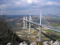 The Millau Viaduct is the worlds tallest vehicular bridge. Spanning the valley of the River Tarn near Millau in southern France, this cable stayed road bridge first opened for traffic on 16 December 2004. The roadway has a slight slope of 3% descending from south to north, and curves in plan section on a 20 km (12.4 mile) radius to give drivers better visibility. It carries two lanes of traffic in each direction. The Millau Viaduct is the worlds tallest vehicular bridge. Spanning the valley of the River Tarn near Millau in southern France, this cable stayed road bridge first opened for traffic on 16 December 2004. The roadway has a slight slope of 3% descending from south to north, and curves in plan section on a 20 km (12.4 mile) radius to give drivers better visibility. It carries two lanes of traffic in each direction.- Pasubio (Vicenza), Northern Italy - a hiking trail made out of an ancient road
- Gergen to Oslo, Norway
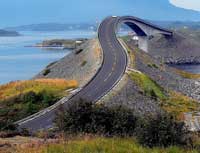 The Atlantic Road, Norway, was voted as the Norwegian construction of the century and is a five mile long stretch of road connecting Molde and Kristiansund. The road rides above some rough and uneven surfaces and it’s spectacular because it rises and falls like a sea itself. Stunning scenery. The Atlantic Road, Norway, was voted as the Norwegian construction of the century and is a five mile long stretch of road connecting Molde and Kristiansund. The road rides above some rough and uneven surfaces and it’s spectacular because it rises and falls like a sea itself. Stunning scenery.
Google map here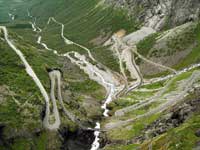 Trollstigen in Norway Trollstigen in Norway
The Trollstigen or ‘The Troll Ladder’, is a steep (9%) winding mountain road located in the Rauma region of Norway. Drivers are rewarded with a viewing balcony at the top, offering views of the winding road and the Stigfossen waterfall which also runs down the mountainside. Google map here- Lysebotn Road, Norway
The Lysebotn Road in Lysefjord, Norway includes 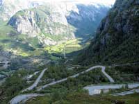 27 hairpins and an impressive 1.1 km long tunnel at the bottom - with 3 hairpins of its own. The last 30 km (18 miles) to Lysebotn is a roller-coaster. The road ends with a 27 hairpin serpentine road taking you from 1000 meters (3280 ft) above sea level down to Lysebotn and the Lysefjord. At the end of the serpentine road you go through a tunnel that turns 340 degrees through the mountain. Google map link here 27 hairpins and an impressive 1.1 km long tunnel at the bottom - with 3 hairpins of its own. The last 30 km (18 miles) to Lysebotn is a roller-coaster. The road ends with a 27 hairpin serpentine road taking you from 1000 meters (3280 ft) above sea level down to Lysebotn and the Lysefjord. At the end of the serpentine road you go through a tunnel that turns 340 degrees through the mountain. Google map link here
- Hairy Bikers Bakeation - Norwegian route here
- Transfăgărășan, Romania. The highest road in Romania, it reaches almost 2000 m above the sea level & connects Muntenia and Transilvania, two historic parts of Romania. At its top you can find Lake Balea, a glaciar lake formes thousands of years ago. The ruins of Poienari Castle, Vlad the Impaler’s real castle, also lie on this route.
- Down South Island (534km), NZ -
Karamea , Westport, Bay House cafe, Punakaiki. The highway turns inland at Haast; leave it to follow the tiny oceanside road to Jackson’s Bay - have some fish and chips from the caravan there. Google Map here. Click here for the Times article.
- Twizel to Queenstown, New Zealand
- Havana to Pinar del Rio, Cuba.
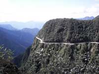 El Camino de la Muerte, Bolivia El Camino de la Muerte, Bolivia
Deep into the Bolivian Andes is the North Yungas Road, the road covers a 70km stretch between La Paz and Coriocco over a decent of 3,600m which pits drivers against terrifyingly tight hairpins and narrow passages. All whilst trying to avoid a 800 m sheer drop. On average, there is a fatal accident every couple of weeks, with the visible remains of numerous lorries and buses at the bottom of the abyss..- El Espinazo Del diablo, Mexico (The devil’s backbone)
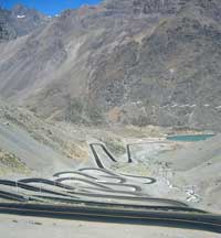 Los Caracoles Pass in Andes Los Caracoles Pass in Andes
The Los Caracoles passes through the Andreas Mountains on the way between Chile and Argentina.The pass features a number of sharp hairpins, with no safety barriers and snow forecast for most of the year. A double-decker tourist buses travels the route on a daily basis.- Leh–Manali Highway, India
- Russia’s Lena Highway, the Highway from Hell
- Russian-Georgian “Military” Mountain Roads (to be tackled only by the Russian military)
- Guoliang Tunnel Road, China
 Located high in the Taihanf Mountains in the Hunan Province of China. Built by 13 local villagers, the tunnel took around 5 years to build and cost the lives of many villagers in the process. At 1200m long by 5m high and 4m wide, the tunnel has earned its name as one of the most dangerous roads in the world, but hugely popular among Chinese tourists and is a stunningly beautiful scenic route. Located high in the Taihanf Mountains in the Hunan Province of China. Built by 13 local villagers, the tunnel took around 5 years to build and cost the lives of many villagers in the process. At 1200m long by 5m high and 4m wide, the tunnel has earned its name as one of the most dangerous roads in the world, but hugely popular among Chinese tourists and is a stunningly beautiful scenic route.
- Taroko Gorge Road in Taiwan (Chungheng)
- The Halsema Highway in the Philippines, also called the Baguio-Bontoc Road
- Van Zyl’s Pass, Namibia, a classic extreme road
- Cape Town to Kruger National Park - see here for details, or here for the Google map. Click here for the Times article.
- The South Africa Garden route from Port Elizabeth to Cape Town - see here for details, or here for the Google Map
- Cape Town to Franschhoek, over the Helshoogte pass, South Africa
-
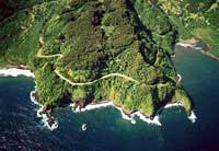 Hana Highway, Maui. Hana Highway, Maui.
The Hana Highway is a 60 mile stretch of road that connects the small town of Hana to the rest of Maui. The Hana Highway winds its way past waterfalls, beaches, bridges and spectacular ocean views. With it’s 600 hairpin turns and 54 one-lane bridges, blind bends, and narrow pavement edged by cliffs, the Hana Highway makes for a challenging yet satisfying ocean drive.
 Iroha-zaka, Japan Iroha-zaka, Japan
The winding road of the Iroha-zaka is the main route that connects central Nikko and Oku-Nikko. Actually made of two roads, one to come down and another to go up, comprising of 48 curves, the road has an ancient Japanese alphabet character displayed on each corner starting with l-ro-ha (hence the name).- Toyo Tires Turnpike, Hakone, Japan. See the Google Map here, and a review here.
- Jebel Hafeet Mountain Road,
United Arab Emirates (UAE)
The Jebel Hafeet Mountain Road spans 7.3 miles and climbs nearly 4,000 feet, 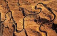 boasting 60 corners. The road is cut into the Jebel Hafeet mountain that spans the border with Oman and lies about 90 minutes’ drive south-east of the thriving city of Dubai. The road is a mixture of fast straights interspersed with sweeping curves that merge perfectly from one to another. boasting 60 corners. The road is cut into the Jebel Hafeet mountain that spans the border with Oman and lies about 90 minutes’ drive south-east of the thriving city of Dubai. The road is a mixture of fast straights interspersed with sweeping curves that merge perfectly from one to another.
- Leh–Manali Highway, India - crosses some of the highest mountain passes in the world.
For more websites with more ideas, see my link page here. See also the Top Gear article here (JPG image) and the following extracts (these routes are all included in the lists above).
In
search of highways to heaven |
The Times, THURSDAY
MAY 10 2001
BY ANDREW NORFOLK
LONELY 45-mile stretch of road in the northern Pennines
has been catapulted to fame after appearing on a list
of the world's most beautiful drives.
The
winding journey from Penrith to Corbridge was the
only English route to be chosen by the Automobile
Association for its Ten Great Drives list. It also
chose a road in Scotland and another in Wales. Other
entries ranged from a spectacular Alpine road in France
to America's famous Highway 50, which crosses the
Nevada desert.
For
Cumbria and Northumberland, whose tourist economies
have been hit hard by the impact of foot-and-mouth
disease, the AA's decision to highlight the cross-county
route came as a welcome boost. The Northumbria Tourist
Board said yesterday that it was delighted to be on
the list.
The
list of "the world's most beautiful roads", published
in the AA magazine, describes the Penrith to Corbridge
journey as a trip through "England's last great wilderness"
The
route, which is mainly along the A686, passes across
the River Eden valley, then climbs from Melmerby to
Hartside Cross, 1,900ft above sea level "with stunning
views across Solway Firth to Scotland". It continues
to Alston, "a charming little place with cobbled streets"
which is the highest market town in England, then
crosses "another breathtaking expanse of windswept
upland before running down to the River Allen's beautiful
wooded gorge", finally passing through Hexham to Corbridge.
Neil
Wishart, landlord of the roadside Carts Bog Inn, said
that he was already anticipating extra visitors.
Mr
Wishart, who has lived and worked alongside the road
for 13 years, said that the route was already popular
with driving enthusiasts, including motorcyclists
from Germany and Scandinavia. "Some of the manufacturers
use it to test their cars and at weekends we see E-type
Jaguars, Lamborghinis and Porsches out to stretch
their legs," he said. "The road goes over the backbone
of the Pennines. On a clear day there are beautiful
views."
The
Welsh road included on the list is the 55-mile journey
from the small border town of Presteigne to Aberystwyth
on the coast. In Scotland the AA opted for a 320-mile
trek with "spellbinding scenery" from Fort William
to Tongue.
Also
in the top ten are three French roads, including the
Great Alpine Road from Evian to Nice, and one each
in Ireland, Spain, Germany and the United States.
Jeremy
Clarkson, the motoring broadcaster, said that his
favourite British road was not the Penrith to Corbridge
route - "a good road, but too busy" - but, instead,
Buttertubs Pass between Hawes and Thwaite in the Yorkshire
Dales. "It's England's only truly spectacular road,"
he said. "I
once raced a helicopter in a Jaguar along there. You
can do it in ten minutes if you really cane it, but
you do tend to hit a few sheep." |
Mazda6 - Six Of The Best Roads
This website actually describes a journey from St Andrews, down
the western side of the UK, flowing through:
1. A68, Edinburgh. Crossing the Forth road bridge, with the famous
rail bridge alongside, past Edinburgh taking the A68, towards
the Borders.Past Jedburgh, heading for the Cheviot Hills, Northumberland
and England.
2. B6318, Otterburn.Take the A696 where the road splits at Otterburn,
then cross-country on the squiggly B6309 to the B6318. Often it’s
arrow straight, but never boring as it climbs and dips through
wild, beautiful countryside. What makes the B6318 special is what
runs alongside Hadrian’s Wall and the old Roman forts at
Chesters, Housesteads and Vindolanda.
3. A686, Gilderdale Forest - Penrith. From halfway along the
Wall, turn south west onto one of the best of all British roads,
the A686, over the fells, through Gilderdale Forest to Penrith.
4. A6, Penrith-Kendal For over thirty miles the A6 winds across
moors and fells. This road was the main North-South road before
the M6 was built.From Penrith it climbs steadily until the village
of Shap. At over 1300 feet, Shap Summit is the highest point,
and in winter one of the wildest. There's a spectacular run into
Kendal with huge views and more great driving. It’s an ancient
town, largest in Westmorland and eastern gateway to the Lake district.
From Kendal take the M6 for a fast run past Lancaster, Preston,
Wigan and Warrington, then switch motorways, west towards Chester
on the M56, south on the M53, to the A483 - winding south along
the Welsh borders in and out of Wales itself, past Wrexham, Oswestry,
Welshpool, Newtown, Llandrindod Wells and Builth Wells. And finally,
cross-country towards Brecon, along a few miles of A40.
5. B4560, Brecon
6. A272, Winchester. Leave Wales by the A40 and A449, onto the
M4 over the new Severn bridge. And a choice of great roads:
a. west again and Devon and Cornwall are packed with options
b. east towards Salisbury Plain,
c. Winchester. and the A272, this runs from Winchester to east
of Uckfield. It was the major part of the old Pilgrim’s route
between Canterbury and Winchester. |

 The
The Miami to Key West
 The Millau Viaduct is the worlds tallest vehicular bridge. Spanning the valley of the River Tarn near Millau in southern France, this cable stayed road bridge first opened for traffic on 16 December 2004. The roadway has a slight slope of 3% descending from south to north, and curves in plan section on a 20 km (12.4 mile) radius to give drivers better visibility. It carries two lanes of traffic in each direction.
 The Atlantic Road, Norway, was voted as the Norwegian construction of the century and is a five mile long stretch of road connecting Molde and Kristiansund. The road rides above some rough and uneven surfaces and it’s spectacular because it rises and falls like a sea itself. Stunning scenery.
 Trollstigen in Norway
 27 hairpins and an impressive 1.1 km long tunnel at the bottom - with 3 hairpins of its own. The last 30 km (18 miles) to Lysebotn is a roller-coaster. The road ends with a 27 hairpin serpentine road taking you from 1000 meters (3280 ft) above sea level down to Lysebotn and the Lysefjord. At the end of the serpentine road you go through a tunnel that turns 340 degrees through the mountain. Google map link
  El Camino de la Muerte, Bolivia
 Los Caracoles Pass in Andes
 Located high in the Taihanf Mountains in the Hunan Province of China. Built by 13 local villagers, the tunnel took around 5 years to build and cost the lives of many villagers in the process. At 1200m long by 5m high and 4m wide, the tunnel has earned its name as one of the most dangerous roads in the world, but hugely popular among Chinese tourists and is a stunningly beautiful scenic route.
 Hana Highway, Maui.
 Iroha-zaka, Japan
 boasting 60 corners. The road is cut into the Jebel Hafeet mountain that spans the border with Oman and lies about 90 minutes’ drive south-east of the thriving city of Dubai. The road is a mixture of fast straights interspersed with sweeping curves that merge perfectly from one to another.